|
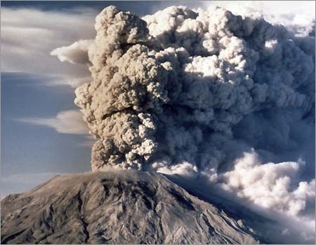
MOUNT ST. HELENS
AN INCREDIBLE STORY THAT
HELPS US TO UNDERSTAND THE FORMATION OF THE GRAND CANYON!
The following is a
partial copy of an article written by Steven A. Austin, Ph.D.
Dr. Austin is on the staff of the Institute for Creation Research:
|
Mt. St. Helens
and Catastrophism (#157)
by Steven A. Austin, Ph.D.
Abstract
The eruption of Mount St.
Helens in Washington State on May 18, 1980, is certain
to be remembered as one of the most significant geologic
events in the United States of the 20th century. The
explosion, on May 18, was initiated by an earthquake and
rockslide involving one-half cubic mile of rock. As the
summit and north slope slid off the volcano that
morning, pressure was released inside the volcano -
where super hot liquid water immediately flashed to
steam. The northward-directed steam explosion released
energy equivalent to 20 million tons of TNT, which
toppled 150 square miles of forest in six minutes. In
Spirit Lake, north of the volcano, an enormous water
wave, initiated by one-eighth cubic mile of rockslide
debris, stripped trees from slopes as high as 850 feet
above the pre-eruption water level. The total energy
output, on May 18, was equivalent to 400 million tons of
TNT - approximately 20,000 Hiroshima-size atomic bombs.
The eruption of Mount St. Helens
in Washington State on May 18, 1980, is certain to be
remembered as one of the most significant geologic
events in the United States of the 20th century. The
explosion, on May 18, was initiated by an earthquake and
rockslide involving one-half cubic mile of rock. As the
summit and north slope slid off the volcano that
morning, pressure was released inside the volcano -
where super hot liquid water immediately flashed to
steam. The northward-directed steam explosion released
energy equivalent to 20 million tons of TNT, which
toppled 150 square miles of forest in six minutes. In
Spirit lake, north of the volcano, an enormous water
wave, initiated by one-eighth cubic mile of rockslide
debris, stripped trees from slopes as high as 850 feet
above the pre-eruption water level. The total energy
output, on May 18, was equivalent to 400 million tons of
TNT - approximately 20,000 Hiroshima-size atomic bombs.
On May 18 and also during later
eruptions, critical energy thresholds were exceeded by
potent geologic processes which were able to accomplish
significant changes in short order. These processes
challenge the traditional uniformitarian way of thinking
about how the earth works, and serve as a miniature
laboratory for catastrophism. Institute for Creation
Research scientists have spent three summers
investigating the geologic changes which have occurred
at the volcano. Four of the most significant discoveries
are summarized in this short report.
RAPIDLY FORMED STRATIFICATION
Up to 400 feet thickness of
strata have formed since 1980 at Mount St. Helens. These
deposits accumulated from primary air blast, landslide,
waves on the lake, pyroclastic flows, mudflows, air
fall, and stream water. Perhaps the most surprising
accumulations are the pyroclastic flow deposits amassed
from ground-hugging, fluidized, turbulent slurries of
fine volcanic debris, which moved at high velocities off
the flank of the volcano as the eruption plume of debris
over the volcano collapsed. These deposits include fine
pumice ash laminae and beds from one millimeter thick to
greater than one meter thick, each representing just a
few seconds to several minutes of accumulation. A
deposit accumulated in less than one day, on June 12,
1980, is 25 feet thick and contains many thin laminae
and beds. Conventionally, sedimentary laminae and beds
are assumed to represent longer seasonal variations, or
annual changes, as the layers accumulated very slowly.
Mount St. Helens teaches us that the stratified layers
commonly characterizing geological formations can form
very rapidly by flow processes. Such features have been
formed quickly underwater in laboratory sedimentation
tanks, and it should not surprise us to see that they
have formed in a natural catastrophe.
RAPID EROSION
Erosion during volcanic
eruptions at Mount St. Helens was accomplished by scour
from steam blast, landslide, water waves, hot pumice ash
flows (pyroclastic flows), and mudflows. Since the
eruptions, the erosion process has been dominated by
sheet flooding and channelized flow of water, with
occasional mudflows. About 23 square miles of the North
Fork of the Toutle River Valley was obstructed by
two-thirds cubic mile of landslide and pyroclastic
debris, which has been rapidly eroded since 1980.
Jetting steam from buried water and ice under hot pumice
reamed steam explosion pits with associated mass-wasting
processes at the margins of pits, producing rills and
gullies over 125 feet deep. Photographic documentation
assembled by ICR scientists demonstrates that very
pronounced rills and gullies had formed at the margins
of seam explosion pits before May 23 - less than five
days after the pumice was deposited. The rills and
gullies resemble badlands topography, which geologists
have usually assumed required many hundreds or even
thousands of years to form.
Mudflows, from Mount St. Helens,
were responsible for the most significant erosion. A
mudflow on March 19, 1982, eroded a canyon system up to
140 feet deep in the headwaters of the North Fork of the
Toutle River Valley, establishing the new dendritic
pattern of drainage. As ICR scientists surveyed this new
terrain, they began to contemplate the processes which
may have formed the Grand Canyon of the Colorado River.
The little "Grand Canyon of the Toutle River" is a
one-fortieth scale model of the real Grand Canyon. The
small creeks which flow through the headwaters of the
Toutle River today might seem, by present appearances,
to have carved these canyons very slowly over a long
time period, except for the fact that the erosion was
observed to have occurred rapidly! Geologists should
learn that, since the long-time scale they have been
trained to assign to landform development would lead to
obvious error on Mount St. Helens, it also may be
useless or misleading elsewhere.
UPRIGHT DEPOSITED LOGS
The landslide generated waves on
Spirit Lake stripped the forests from the slopes
adjacent to the lake and created an enormous log mat,
made up of millions of prone floating trunks that occupy
about two square miles of the lake surface. These logs
float freely as the wind blows them, and the decreasing
size of the log mat indicates that the trees are
gradually sinking to the lake floor. Careful observation
of the floating log mat indicates that many trees float
in upright position, with a root ball submerging the
root end of the trunk, while the opposite end floats out
of the water. Hundreds of upright floated and deposited
logs have been grounded in shallow water along the shore
of the lake. These trees, if buried in sediment, would
appear to have been a forest which grew in place over
hundreds of years, which is the standard geological
interpretation for the upright petrified "forests" at
Yellowstone National Park.
In order to get more information
on the upright deposited logs in Spirit Lake, members of
the ICR research team worked with Dr. Harold Coffin, of
Geoscience Research Institute, to survey the lake
bottom, using sonar and scuba. Hundreds of upright,
fully submerged logs were located by sidescan sonar, and
scuba divers verified that they were, indeed, trunks of
trees which the sonar detected.
Extrapolating from the area of
lake floor surveyed to the entire lake bottom, we
estimate more than 19,000 upright stumps existed on the
floor of the lake in August 1985. The average height of
an upright deposited stump is 20 feet. Sonar records and
scuba investigations verified that many of the upright
deposited trees have root masses radiating away from the
bases of the trunks. Furthermore, the trees are randomly
spaced, not clumped together, over the bottom of the
lake, again having the appearance of being an in situ
forest. Scuba investigation of the upright deposited
trunks shows that some are already solidly buried by
sedimentation, with more than three feet of sediment
around their bases, while others have no sediment around
their bases. This proved that the upright trees were
deposited at different times, with their roots buried at
different levels. If found buried in the stratigraphic
record, these trees might be interpreted as multiple
forests which grew on different levels over periods of
thousands of years. The Spirit Lake upright deposited
stumps, therefore, have considerable implications for
interpreting "petrified forests" in the stratigraphic
record.
|
To see the entire
article written by Dr. Austin, click below:
http://www.icr.org/index.php?module=articles&action=view&page=261
SUGGESTED RESOURCES:
BOOKS
.
Refuting Evolution
by
Jonathan Sarfati, PH.D
Published in 1999 by
Master Books Inc. POBox 727 Green Forest, AR 72638
ISBN: 0-89051-258-2
and Library of Congress Number 99-70693
Darwin's Leap of
Faith
(Exposing the False Religion of Evolution)
by John Ankerberg
and John Weldon
Published in 1998 by
Harvest House Publishers, Eugene, Oregon 97402
ISBN: 1-56507-657-5
The Fossils Still
Say No!
by Duane Gish
Published in 1995 by
Institute for Creation Research, El Cajon, CA.
Bones of
Contention: A Creationist assessment of Human Fossils
by Marvin Lubenow
Published in 1992 by
Baker Book House, Grand Rapids
Grand Canyon:
Monument to Catastrophy
Steven A. Austin,
Ph.D., Editor
Published in 1994 by
Institute for Creation Research, Santee, CA.
.
“In The Beginning: Compelling Evidence for Creation and the Flood”
by Walt Brown
VIDEOS
.
Grand Canyon:
Monument to the Flood
this is a companion
video to the Book: Grand Canyon: Monument to Catastrophe
55 Minutes in
Length: Featuring 5 Creation Geologists: Steven A. Austin, Ph.D;
George Van Burbach, Ph.D., John D. Morris, Ph.D; Andrew A. Snelling,
Ph.D, and Kurt P. Wise, Ph.D.
Produced in 1995 by
the Institute for Creation Research. POBox 2667, El Cajon, CA
92021
Mount St. Helens :
Explosive Evidence for Catastrophe
62 Minutes in
length: Narrated by Steven A. Austin, Ph.D.
Produced in 1989 by
Institute for Creation Research. POBox 2667, El Cajon, CA
92021
Dinosaur Mystery
Solved
53 Minutes in
length: Narrated by John D. Morris, Ph.D
Produced as part of
the excellent "Back to Genesis" series of videos
by the Institute for
Creation Research. POBox 2667, El Cajon, CA 92021
the
Kent Hovind series
of Videos -- the Creation Seminar.
These excellent
videos can be viewed on his website or can be ordered at a modest
cost from him at
Creation Science Evangelism, c/0 29 Cummings
Road, Pensacola, Florida, 32503
Toll-Free Order line
877-479-3466
Ken Ham videos
There are many
excellent creation related videos by Ken Ham and others, including a
excellent seminar series. These are available from the Answers In
Genesis website. Please go there for details.
http://www.AnswersInGenesis.Org
|